Travel and flyfishing in the Russian Far East
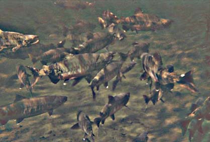
Resting chum salmon in a pool (Yama River, Magadan region)
Resting chum salmon in a pool (Yama River, Magadan region)
A new book - "Flyfishing the Russian Far East"
Out of a chapter "Floating the rivers of the Far East" - part I ("Nakhlyst" magazine, #1, 2004)
“Floating the river baffles all attempts to describe it. It consists out of small events, twisted into monotonous days. In any case, vital parts of it are the day-after-day efforts, cutting flashes of the sun, sharp feeling of danger, which you always realize too late, the banks, heaped up with thousands of dead trees, and the moose, which rest on the pebbles in evenings and start in the last moment, because you move absolutely noiseless.”
Oleg Kuvaev «Home for vagabonds»
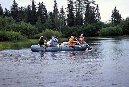
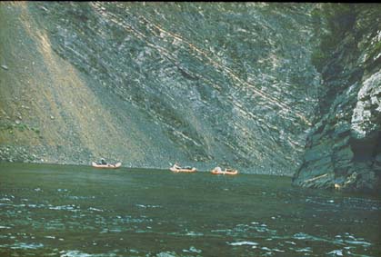
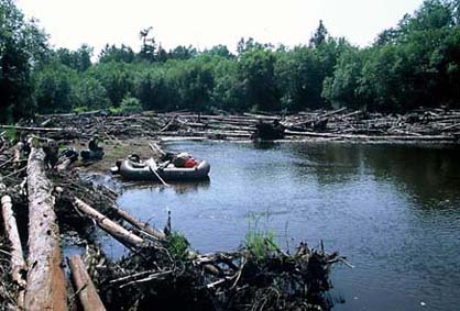
Big rafts can carry up to 6 fishermen
Floating a river with inflatable boats, kayaks or different types rafts is the most convenient (I think) way to travel – if your goal is mostly fishing. Among the Russian fishermen the most popular are small inflatable boats and aluminum motor-boats. I do not like the last because of the noise, and of a danger, which they represent on swift rivers. Tourist kayaks have advantages only on slow rivers and lakes. Once popular log rafts are not more in use in Siberia, but many tourists prefer frame rafts (catamarans, trimarans) with cigar-shape inflatable elements. For serious trips I give preference to inflatable boats with 250-350 kg capacity. It is the best to have one such boat for each group member. It is possible to use the same boats with a crew of two, but in this case it will be difficult to load all gear, necessary for a long trip.
A traveler should know the main characteristics of the rivers, which can have direct impact at his safety and at the journey success in general. In the first row these are water discharge, stream gradient, and sinuosity.
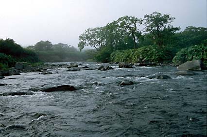
Tyatina River is mountainous even close to the sea (Kunashir, the most southern of the Kuril Islands)
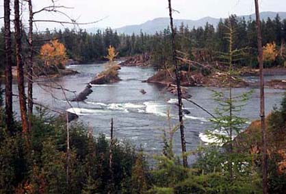
Typical mountainous and piedmont streams of the Russian Far East flow in valleys with flat, trough-shaped bottom, which consists mostly out of pebbles. Such rivers are dividing into numerous channels and form so called braids. Many of these channels are unsteady – the river can seriously change even during one flood. The main channel is often shifting from one valley side to another. For instance, at the map the river flows along the steep right bank. You come to that area and see, that all water now flows a kilometer to the left – as several narrow channels. Now this area is dry and looks like long stretches of gravel separating the islands of poplar forest.
Current speed of the braided rivers with the gradient of 2-3 m/km is normally 4-7 km/h. If the gradient is about 5 m/km, current speed will be 6-9 km/h. During floods these numbers will be about 50% higher. So, in the upper reaches of the Inya River (north of Khabarovsk region) the average current speed during a rain-flood was over 11 km/h, and the maximum – 15 km/h. Sinuosity of such streams is low – the channel length does not exceed the length of the valley more than 1,5 times. In such rivers with an inflatable rowing boat you can make up to 40-50 km a day – if you will not meet log jams or complicated rapids.
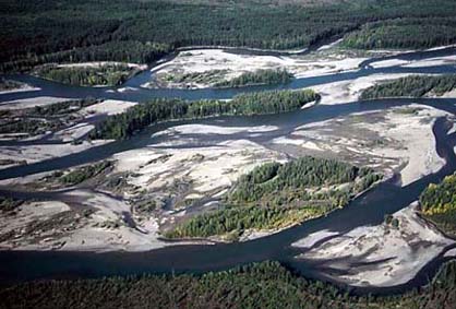
Yudoma River in the middle reaches: this is a braided area with multitude of channels and pebble islands
The rivers flowing through canyons are in the Far East rather rare. Such is the outlet of the mysterious Elgygytgyn Lake – Enmyvaan River, which belongs to the Anadyr drainage. A swift Omulevka River (left tributary of the middle reaches of the Kolyma) flows through several deep canyons with complicated falls. The deepest and most spectacular canyon of the whole region is created by Paren River, which flows into the north-eastern corner of the Sea of Okhotsk. Many other rivers with trough-shaped valleys have short canyon stretches. Canyons and any valley narrows in general often have rapids and even falls. If we compare a river with braided valley, and the one with the falls - with the same gradient, the average current speed in the first one will be much higher. If the big share of the river gradient is concerned with the falls, there will be slow sandy pools between them.
Dikiy Porog (Wild Falls) at the Yudoma River (Lena drainage)
The Paren River canyon is the deepest in Magadan region
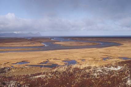
Rivers which flow on the plains, on flat tundra areas or in swamps have small gradient (less than 0,5 m/km); normally they have only one channel and often meander. These meandering rivers coil and wriggle, form loops and nearly knots. The travel distance along such a river can 5-7 times exceed the length of the valley. This index is called “sinuosity factor”. Considering low current speed of such rivers, floating can take lots of time and effort, especially in case of cross-wind. Straight line 20 km on a map can become over 100 km on almost stagnant water!
A marshy Evur River near its mouth at the Evoron Lake. This is what is called the meanders. If you see this on a map, prepare the tackle for the pike.
Silted areas with slack current and almost no gradient are found close to the lakes, upstream from them. The same shape can have side channels of lowland rivers. Such channels are situated in vast valleys far from the main river, or these can be the former river-beds and sloughs with not much flow. Tidal areas have small gradient, sandy bottom and alternating current. For half of a day the river can look normal. All of a sudden it stops, starts flowing backwards, and floods the islands. This phenomenon is especially characteristic for the coast of the Sea of Okhotsk, where the tides can reach 13 meters! Tidal areas of some rivers are rather swift during the low tide, others are deep and slow around the clock.
Snatolvayam River (north-western Kamchatka) in the tidal zone.
How should you start planning a float-trip? First try to pass the route on the map. At that you should be able to calculate the river gradient from the contour lines, assess the river peculiarities, which will allow estimating the traveling speed.
The maps with 1:100 000 scale have lots of additional or hidden information. When examining your route on the map, you can get an impression on how the river will look. It is possible to on the river. For instance, the river stretches, denoted with a double line, are wider than 20 m and normally passable for rafts. The rivers and creeks denoted with single blue lines could be too small for floating, or have lots of log jams. The distance from the river sources will allow you to reckon, how fast the flood wave from a strong rain will reach the travel area, for how long the river will become non-fishable, and how fast the flood will go down. It is necessary to take into account how much the river flow is “regulated” by the lakes and (or) swamps in the watershed. So, some rivers flowing through big lakes and marshy areas never get murky, and their water level does not change much. Other streams (especially the ones with high mountains in the watershed) are affected by several mighty floods every summer and fall.
Junction of Konin and Assyni Rivers: from here starts the Tugur River.
Mountainous streams in floods become murky, but the rivers with dark colored water stay clear. Here you can expect to catch fish even during the high ware periods.
Many streams of the mountainous type, with clear blue or green water, become murky after every serious rain. Colored marshy rivers in the same conditions often stay clear. Try to find areas, where even during big floods the water will be clear enough. These are the junctions with the lake outlets, with slow or stagnant side-channels. Such places could provide good fishing even during high-water period, when the main river is coffee-colored and carries driftwood.
When we were choosing location for the fishing lodge at the Yama River near Magadan, this consideration has determined the final decision – to place it in the mouth of a tributary - Studenaya River. Yama is a clear mountainous stream; in high floods it becomes murky. The distance from the lodge to the river sources is about 200 km, so the water is starting to go down on the second day after the rains stops, and come to normal level in not less than 5 days. Studenaya is a marshy type river with tea-colored water and not too high gradient. In big floods on the main river the mouth of Studenaya becomes a deep, quiet bay – resting place for different fish. Because of this the fishing near the Yama lodge is always good – regardless to the water level in the river.
Tourists divide all rivers into 6
categories, according their difficulty for rafting. Streams of category 1 are
slow, have low gradient, lots of them are navigable by commercial boats. The
best way to travel on such rivers is the use of a motor-boat or motor ship. Use
of a rowing boat is here hard and, I think, boring.
Even
small wind, especially cross-wind, will raise the waves.
Besides
that, in such places it is normally only few salmonids, the predominant fish
species will be whitefishes and cyprinids, pike and burbot. The most convenient
streams for amateur travelers are those of 2nd category. For category 3 the
requirements to the level of outdoor skills of the group are rather high. The 4
category is within the grasp of a well-trained rafters group with reliable
equipment. The rivers of 5th and 6th categories are swift streams with series of
complicated rapids and falls, often situated in canyons. They offer
neck-breaking routes primarily for the lowers of extreme games. Although in some
of these streams the fishing could be good as well.
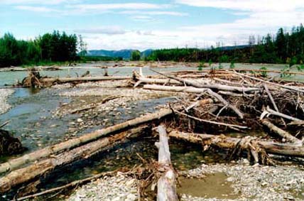
Old logjam at the Konin River. This is the point where we have had to start portage.
However, the main dangers on the rivers, where we travel in search for big fish, represent not the rapids. Swift areas add diversity to your route, and they are attractive from the fishing point of view. When traveling along a forest river, after rowing long slow stretches nothing is more pleasant than water murmur on riffles. This area offers biggest chances of a bite of all salmonids, including longed-for Siberian taimen. Only the inlets can be more productive for taimen fishing than the falls.
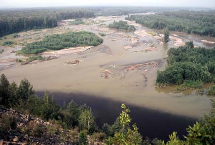
Our main “enemies”, which I even see sometimes in my dreams, are the log-jams. Most of the accidents, which occur on the rivers, are caused by log-jams or “combs” – it is a nickname of a tree bent over the water. By the way, when going downriver, it is more dangerous to use a motor-boat than a rowing rubber raft.
Some log-jams are huge and old, they exist for tens of years; local people know all of them well. Old log-jams often block the river completely, tree trunks form a dam. The current slows down; the water spreads into small channels, which go around the blocked area. Such an obstacle is not dangerous, although it often requires big efforts for the portage of boats and gear. It is necessary to unload the boats and rafts and sometimes to take them apart. After that the group will have to look for a roundabout trail or to cut it through the forest, and to portage all gear downstream - to the free stretch of the river. Some obstacles of this type take days to pass…
The most dangerous are the jams in new river channels – the ones created by the river not long ago. Such channels are often more deep, swift and narrow comparing with the old ones, “developed” by the stream. The banks of such channels are often steep and sloughing; in many places it is hard or impossible to land or even stop. A channel passable a month ago could be blocked by fallen trees or driftwood after one flood.
The ability to distinguish old and new channels is especially important for fishermen which float an unfamiliar river without a guide. If the river in front of me is dividing into two more or less equal size channels, I will always turn into the one with wide pebble bars. Sometimes it is a good idea to choose a smaller channel – to avoid the one which is bigger but looks dangerous. Be careful if the both banks of the channel are steep and consist of soil. The worst signs of danger are green trees, bent to the water, or washing their tops in the river. This channel is very young for sure; it is a big risk to enter it without reconnaissance. If there is no other way and you will have to float through such a channel, it is necessary to stop in a safe place and to check it from the bank – prior to floating.
Lots of logjams form immediately below the areas where the river is destroying old forest. So, if you are passing a sloughing bank with huge trees inclined above the river, it is likely to expect a “bad” logjam. Beneath most of the young jams the water is swift; in such places it is easy to loose boat and gear, or even to drown. Another sign of danger is the low height of the gravel bars and islands above the water. The river is starting to look as in the flood – water comes up to the tree roots, floods the islands, overflow the river banks. I think, that the river is pushing and moving downstream a swell of pebbles. This swell is displacing the water, forcing it to destroy the islands.
Be very careful in swift areas with low islands and banks. On the contrary, the areas with high pebble bars and islands, covered by unharmed forest, are stable and much safer for floating. Such areas are recommended for the camping as well. We have to talk about the choice of the campsite, which is not that easy on some rivers, and could be critical for your safety. The main question is how high above the river you could stay. You should be able to imagine, how fast the water level in this given stream can come up. If possible, I am always trying to camp at least 1 meter above the water. This is not necessary on the banks of huge lowland rivers – they can not come up fast. Short mountainous streams flowing in narrow valleys are much more dangerous. And even in some big rivers the water level can rise swiftly. For instance, such are the rivers, which flow on permafrost, as many rivers of Yakutia. Not much of the rain water will seep into the frozen soil – almost every drop will be in the river. This can trigger a sudden, unexpected flood, which could come at night and do much harm. For instance, there were cases when the tourists had lost their boats with food and gear on tributaries of the Aldan River. The rule number one is: ALWAYS tie your boat or anchor it. Even if the sky is clear, the rain could have already fallen somewhere in mountains, and the river could come up 2 meters during one night! If you are floating of camping on a tidal stretch of a river, be careful as well. The biggest tides in the region are observed in the Sea of Okhotsk, especially in the Penzhina Bay and in the west of the sea – near mouths of Tugur and Uda Rivers.
A dangerous stretch of the Nonna (Inya) River. If you see such wood-piles at the bars, look for a logjam.
It is necessary to talk about one more phenomenon of the northern nature - the ice-crust. In winter lots of our rivers in shallow places freeze through - to the bottom. Flowing water comes to the ice surface and freezes on its top. During long harsh winters multi-meter layers of ice could form. In some valleys this process forms huge ice-crust: tens of kilometers long and several kilometers wide. Such ices in river valleys are especially common in Chukotka, Magadan region and Yakutia. In the first half of summer the ice-crust can become a serious obstacle for rafters. Rivers cut in it narrow channels with steep banks, which can suddenly collapse. Most dangerous are the places, where the water goes under the ice, forming tunnels. If you have come to the ice-crust and can not see if it is passable, stop and make reconnaissance.
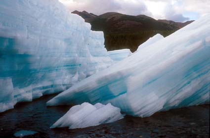
Ice-crust at the Dzugzdzhaka River (Upper Kolyma) in July. This is a hard place to pass.
There is one more river index important for travelers – the “danger factor”. This is product of multiplication of the water discharge (in cubic meters per second) by the river gradient (in meters per kilometer). All rivers are divided into 6 categories or classes – according to their difficulty for rafting. In contrast to this constant index, the “danger factor” can seriously change depending on the water level in the river. For instance, Inya River in the upper reaches has 7 m/km gradient. In low water period the water discharge in the river can be about 10 m3/sec. The “danger factor” in this case is 70, which is quite a lot. After a rain this factor will become much higher - despite the fact that the river will still belong to the same 3 class. But the real difficulty (and danger!) for the rafters in the flood period will increase many times! If you compare the danger factors of a river which you know and of the one where you are going to go, it is possible to reckon what you will face.
Thus, rivers in the flood are more dangerous. If it is possible, avoid floating in high water period, and always let the flood crest pass through. The most dangerous are such water levels, when the river carries lots of driftwood. It is better to loose several days, than to risk your life. In the flood it is necessary to keep to the main river channels and not to turn off into unknown side-channels. High water makes temporary channels passable, but many of them go into nowhere, disappearing in the forest.
Chapters of the book: Organization of wilderness trips
Zonation of the Russian Far East
Articles posted at this web-site
Glossary - fish Glossary - fishing
Home Fishing Flies Books & Articles Fishing tours About the author