Travel and flyfishing in the Russian Far East
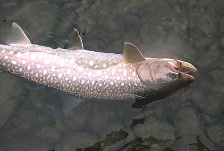
Kundzha or white-spotted charr can be over 15 kg!
This is part of a chapter of a new book -
Flyfishing the Russian Far East
Chukotski Peninsula (Chukotka)
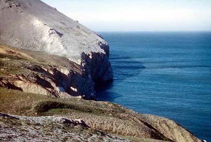
Dezhneva Cape - the most northeastern point of Asia
Treeless eastern Chukotka is the territory adjoining the Bering Strait and situated close to Alaska. This part of Asia has reached far into the Western Hemisphere. The north-eastern tip of Asia is called the Dezhneva Cape. This is an amazing place: you are standing high above the sea with the whole Asian continent behind you. On a sunny day one can see the Big Diomid (Russia) and Little Diomid (USA) islands in the strait and the cost of Alaska. The distance between two continents is here only 40 miles. On the left hand you see the Polar Ocean, and on the right is the Pacific!
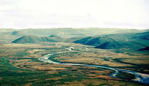
Upper reaches of the Amguema River
Chukotka has very cold, harsh climate and is mostly mountainous. Fly-fishing season is short: the rivers flow from June till September, and the ice on the lakes can stay till August. Sport-fishermen catch here mostly anadromous Dolly Varden and Arctic charr, and also lake-resident charrs, which can be big. In some rivers Arctic grayling and Pacific salmon (pink, chum, chinook and sockeye) are present. In several streams and lakes close to the Bering Strait there are populations of the Alaska (American) subspecies of Arctic grayling.
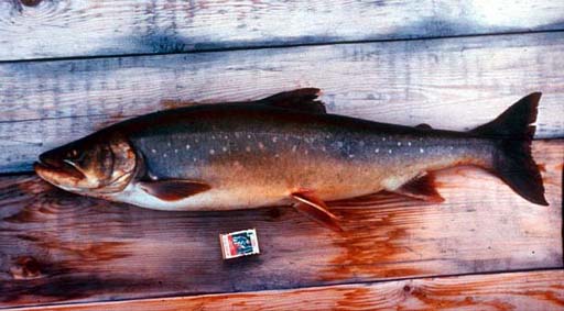
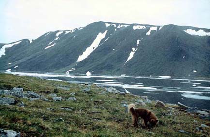
Lake resident charr out of the Yanranaygytgyn Lake (Amguema River drainage)
Chukotka has no roads. Travelers come to its capital, Anadyr, only by air – from Magadan, Khabarovsk or Moscow. The main towns of Chukotka (Egvekinot, Lavrentia, Providenia, and Beringovski) can be reached from Anadyr by domestic flights. The flight schedule depends on weather, which is often bad and always unpredictable.
Koolen Lake
This is a big and deep lake; it is 14 km long and over 100 meters deep. The fish-fauna of the lake includes anadromous Arctic charr, least cisco, and American grayling. The charr of this stock are rather big (up to 7 kg). In the fall these fish are running up the lake outlet – the Koolen River - to spawn and overwinter in the lake. The downriver char migration for the sea occurs in June, during the ice-flood. The river is rather short – its length is about 50 km. In July the only sport-fish in the river is grayling, but in June and August there is a chance to catch big anadromous charr here. This area is not too far (a short helicopter flight) from the district capitol Lavrentia. In the mouth of the river there is a long estuary. At the sea spit between the estuary and the sea is situated the native Chukchee village Uelen. This is a well-known center of carving and engraving art. Traditional material which native carvers use is the walrus tusk.
In July the Koolen Lake can still have floating ice
Chaun River and Pucheveem River
These two streams flow into the Chaun Bay, a big bay of the Polar Ocean, situated above the Polar Circle close to Pevek, which is the only city and a marine port of the area. The rivers enter the Chaun bay in its southern part; this area is about an hour helicopter flight from Pevek. In the mouth of the Chaun River there is a small village Rytkuchi. The rivers flow through flat treeless tundra. The landscape of the area is not spectacular, but is has its own charm.
These rivers used to have a good run of big anadromous Dolly Varden Charr up to 12-15 kg, with 2-3 kg average. There is no information of fly-fishing in these waters.
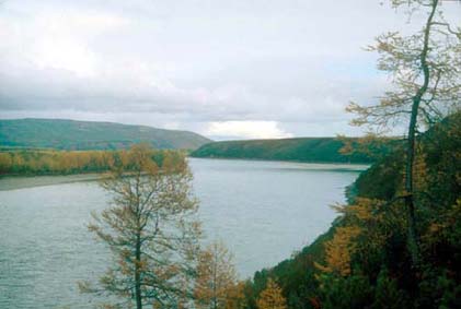
Anadyr River near the Opalennaya mountain upstream from Markovo village (photo - I.Chereshnev)
The biggest river of Chukotka - Anadyr – flows into the Bering Sea. Because of severe climate most of the territory has no forest, only in the upper reaches of the river grow this larch forest. Along the river in its middle reaches there is band-forest out of poplar and Korean willow. The capital of Chukotski Autonomous Okrug (territory), Anadyr, is located in the lower reaches of the river, at the estuary.
The most interesting sport-fish of the region is inconnu (sheefish), it is protected and prohibited to keep. The drainage is home to a big stock of chum salmon – the largest in the Russian Far East. The drainage is famous by numerous, trophy Arctic grayling, inconnu, chum salmon, Northern pike, different whitefishes, and Dolly Varden charr. In the slow channels of the middle and lower reaches of the river live huge Northern pikes, which can even swallow chum salmon.
After reaching Anadyr, you can continue your trip to the villages Markovo or Ust-Belaya, situated in the middle reaches of the river. From Markovo you can go closer to its sources, to the native villages Lamutsk and Chuvansk. Several of the Anadyr tributaries are big rivers, attractive for the travelers.
Upper Anadyr River
The very upper reaches of Anadyr River are an interesting option for a float-trip in true wilderness. Along the way there will be only one small Native village – Lamutskoe. The group can start from the mouth of a big upper tributary - Mechkereva River. The best way to reach the Upper Anadyr is to fly to Magadan and then to the Bilibino town. A helicopter charter from Bilibino will bring you to the river in less than 2 hours. The main quarry of the fishermen will be big Arctic grayling, belonging to the Kamchatka subspecies. In the river will be present chum salmon, Dolly Varden charr (both species in the fall) and whitefishes. On the last days of the trip there is a good chance to catch the inconnu (sheefish).
The trip from Mechkereva to the Markovo village will take at least a week. From here you can fly back to civilization: to Anadyr, then to Moscow, Magadan or Khabarovsk.
Main River
Main is a big right tributary of the Anadyr River. Main has lower gradient and darker water comparing with the Upper Anadyr River. In the middle reaches of the river there is a small native Chukchee village Vaegi. Fishing objects are Arctic grayling, Northern pike, whitefishes (including inconnu), and chum salmon. Pikes in the lower Main are big – over 10-12 kg. Sometimes in the stomachs of the biggest pikes we find chum salmon.
Elgygytgyn Lake
This lake is the most interesting water of North-Eastern Asia. Imagine a treeless territory of Central Chukotka (68°North) with sloping, not steep mountaines. Right on the divide between the Polar Sea and Pacific Ocean these mountains form an exact ring.
This round structure has completely flat bottom - without any hill or rock. About a half of the surface of this ring is filled by water – by a round lake 12 km wide and up to 200 m deep. The lake is 3,5 million years old and has space origin: it was formed by an impact of a huge meteorite. Elgygytgyn is considered the biggest of the young meteorite structures on the Earth surface. On the banks of the lake it is easy to find pieces of black glass-like rocks. These glasses have impact origin and were born in the mighty explosion, which has formed a 17 km crater.
The lake hollow is filled with extremely clear, distilled, almost invisible water. Its transparence is astonishing – it is easy to see the bottom and fish on the depth of 15 m! The lake is extremely cold – the temperature near the bottom is never above 3ºC, and on the surface it is always near freezing. The lake is covered by solid ice for 9 months of the year. Ice breaks in the first days of July, and the drifting ice-floes cover part of the lake till August.
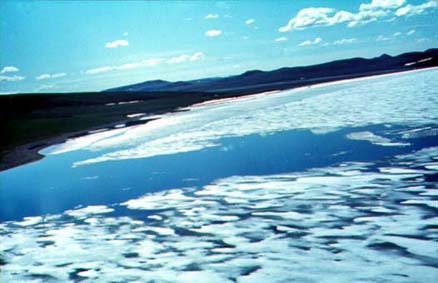
In the beginning of July Elgygytgyn Lake is still covered by ice
The lake is too cold for most fish species to survive, and is inhabited by 3 species of charr (see “Lake-resident charrs from Chukotka”). The only sport-fish of the lake is Boganid charr, which can reach up to 15 kg. It is not difficult to catch big charrs in the south-eastern part of the Lake, in the mouth of the Lagerny Creek and under nearby Pink Cliffs. Fishing here is good from mid June – the lake is covered by ice, but in the creek mouth there will be a big ice-hole.
The lake shores are completely treeless. The climate on this latitude (68ºN) and altitude (500 m) is very severe. On any day of the summer you could expect snow.
Predatory Boganid charr (9,1 kg)
The fish was landed through the ice in the end of June 1986
Enmyvaam River
This picturesque river is the outlet of the Elgygytgyn Lake. It flows mostly south to the junction with the Yurumkuveem River – to form the Belaya River, a big left tributary of the Anadyr. For the first 30 km Enmyvaam flows through the wide valley with flat bottom. Further south the hills come closer, and the river starts to carve its path through the Baranyi Gory (Sheep Mountains). The canyon becomes deeper and more spectacular. On the steep walls and in the openings of the creeks you can often see the wildlife such as caribou, brown bear, or snow sheep. The rapids of the river are not too complicated, but they require some rafting experience. In the upper part the river is treeless, staring from the middle part of the canyon you will see some small alders and willows.
In the river there are lots of trophy Arctic grayling. Dolly Varden charr and chum salmon come here to spawn in the fall. In the lower part of the river there are different whitefishes (including inconnu) and Northern pike.
Enmyvaam River - the outlet of the Elgygytgyn Lake - above the canyon (end of June).
The water is still murky because of the melting snow.
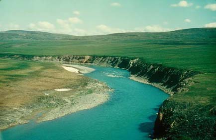
Velikaya River
This huge river is over 600 km long and flows from the south into the estuary of the Anadyr River. The river has villages and no resident population, except two meteorological stations, and native Chukchee reindeer herders. The fishermen’s quarry will be the same as in other tributaries of the Anadyr: grayling, whitefishes, chum salmon and pike. Velikaya has quite a numerous population of inconnu (sheefish).
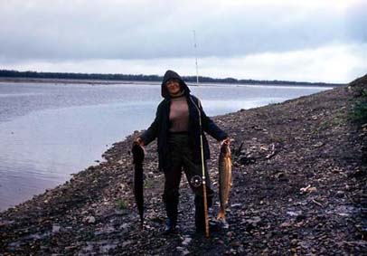
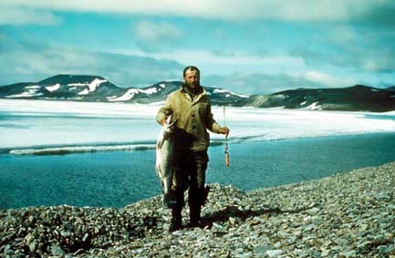
Inconnu (sheefish) and Northern pike, caught in the Velikaya River
Second part of the article Articles posted at this web-site
Home Flyfishing Flies Books & Articles Fishing tours About the author
FLYFISHING, OUTDOOR TRIPS, WILDERNESS PHOTOGRAPHY